www.Liveintheearth.blogspot.com

get hot news about the medical world on this blog

Selasa, 02 Oktober 2007

The Legent of Sea Mosters "Kraken"


Kraken are legendary sea monsters of gargantuan size, said to have dwelled off the coasts of Norway and Iceland. The sheer size and fearsome appearance attributed to the beasts have made them common ocean-dwelling monsters in various fictional works (see Kraken in popular culture). The legend may actually have originated from sightings of real giant squid that are estimated to grow to 13 metres (46 feet) in length, including the tentacles. These creatures normally live at great depths, but have been sighted at the surface and reportedly have "attacked" small ships.
Kraken is the definite article form of krake, a Scandinavian word designating an unhealthy animal, or something twisted.[1] In modern German, Krake (plural: Kraken) means octopus, but can also refer to the legendary Kraken (Terrell, 1999).
History

Although the name kraken never appears in the Norse sagas, there are similar sea monsters, the hafgufa and lyngbakr, both described in Örvar-Odds saga and the Norwegian text from c. 1250, Konungs skuggsjá.[2] Carolus Linnaeus included kraken as cephalopods with the scientific name Microcosmus in the first edition of his Systema Naturae (1735), a taxonomic classification of living organisms, but excluded the animal in later editions. Kraken were also extensively described by Erik Pontoppidan, bishop of Bergen, in his "Natural History of Norway" (Copenhagen, 1752–3).
Early accounts, including Pontoppidan's, describe the kraken as an animal "the size of a floating island" whose real danger for sailors was not the creature itself, but the whirlpool it created after quickly descending back into the ocean. However, Pontoppidan also described the destructive potential of the giant beast: "It is said that if it grabbed the largest warship, it could manage to pull it down to the bottom of the ocean" (Sjögren, 1980). Kraken were always distinct from sea serpents, also common in Scandinavian lore (Jörmungandr for instance). A representative early description is given by the Swede Jacob Wallenberg in his book Min son på galejan ("My son on the galley") from 1781:
"… Kraken, also called the Crab-fish, which [according to the pilots of Norway] is not that huge, for heads and tails counted, he is no larger than our Öland is wide [i.e. less than 16 km] ... He stays at the sea floor, constantly surrounded by innumerable small fishes, who serve as his food and are fed by him in return: for his meal, if I remember correctly what E. Pontoppidan writes, lasts no longer than three months, and another three are then needed to digest it. His excrements nurture in the following an army of lesser fish, and for this reason, fishermen plumb after his resting place ... Gradually, Kraken ascends to the surface, and when he is at ten to twelve fathoms, the boats had better move out of his vicinity, as he will shortly thereafter burst up, like a floating island, spurting water from his dreadful nostrils and making ring waves around him, which can reach many miles. Could one doubt that this is the Leviathan of Job? "
According to Pontoppidan, Norwegian fishermen often took the risk of trying to fish over kraken, since the catch was so good. If a fisherman had an unusually good catch, they used to say to each other, "You must have fished on Kraken." Pontoppidan also claimed that the monster was sometimes mistaken for an island, and that some maps that included islands that were only sometimes visible were actually indicating kraken. Pontoppidan also proposed that a young specimen of the monster once died and was washed ashore at Alstahaug (Bengt Sjögren, 1980).
Since the late 18th century, kraken have been depicted in a number of ways, primarily as large octopus-like creatures, and it has often been alleged that Pontoppidan's kraken might have been based on sailors' observations of the giant squid. In the earliest descriptions, however, the creatures were more crab- like than octopus-like, and generally possessed traits that are associated with large whales rather than with giant squid. Some traits of kraken resemble undersea volcanic activity occurring in the Iceland region, including bubbles of water; sudden, dangerous currents; and appearance of new islets.
In 1802, the French malacologist Pierre Dénys de Montfort recognized the existence of two kinds of giant octopus in Histoire Naturelle Générale et Particulière des Mollusques, an encyclopedic description of mollusks. Montfort claimed that the first type, the kraken octopus, had been described by Norwegian sailors and American whalers, as well as ancient writers such as Pliny the Elder. The 
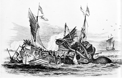
much larger second type, the colossal octopus (depicted in the above image), was reported to have attacked a sailing vessel from Saint-Malo, off the coast of Angola.
Montfort later dared more sensational claims. He proposed that ten British warships that had mysteriously disappeared one night in 1782 must have been attacked and sunk by giant octopuses. Unfortunately for Montfort, the British knew what had happened to the ships, resulting in a disgraceful revelation for Montfort. Pierre Dénys de Montfort's career never recovered and he died starving and poor in Paris around 1820 (Sjögren, 1980). In defence of Pierre Dénys de Montfort, it should be noted that many of his sources for the "kraken octopus" probably described the very real giant squid, proven to exist in 1857.
In 1830, possibly aware of Pierre Dénys de Montfort's work, Alfred Tennyson published his popular poem "The Kraken" (essentially an irregular sonnet), which disseminated Kraken in English forever fixed with its superfluous the. The poem in its last three lines, also bears similarities to the legend of Leviathan, a sea monster, who shall rise to the surface at the end of days.
Tennyson's description apparently influenced Jules Verne's imagined lair of the famous giant squid in Twenty Thousand Leagues Under the Sea from 1870. Verne also makes numerous references to Kraken, and Bishop Pontoppidan in the novel.
Later developments of the Kraken image may be traced at Kraken in popular culture.


news source of www.wikipedia.org
..read more...

The Legent of Sea Mosters "Charybdis"


In Greek mythology, Charybdis or Kharybdis (in Greek, Χάρυβδις) was a sea monster, daughter of Poseidon and Gaia. She takes form as a monstrous mouth. She swallows huge amounts of water three times a day and then belches them back out again creating whirlpools. Charybdis was originally a naiad, sea-nymph who flooded land to enlarge her father's underwater kingdom, until Zeus turned her into a monster. He was angry that she was taking so much of his land and made it so that she would be incredibly thirsty three times a day and suck in the water.
The myth has Charybdis lying on one side of a narrow channel of water. On the other side of the strait was Scylla, another sea-monster. The two sides of the strait are within an arrow's range of each other, so close that sailors attempting to avoid Charybdis will pass too close to Scylla and vice versa. The phrase between Scylla and Charybdis has come to mean being in a state where one is between two dangers and moving away from one will cause you to be in danger of the other. Between Scylla and Charybdis is the origin of the phrase "between the rock and the whirlpool" (the rock upon which Scylla dwelt and the whirlpool of Charybdis) and may be the genesis of the phrase "between a rock and a hard place".
The Argonauts were able to avoid both dangers because they were guided by Thetis, one of the Nereids. Odysseus was not so fortunate; he chose to risk Scylla at the cost of some of his crew rather than lose the whole ship to Charybdis. (Homer's Odyssey, Book XII). Odysseus successfully navigated the strait, losing only six men to Scylla. However, the men offended Helios by killing the god's sacred cattle, and Zeus retaliated by destroying ship and crew with a thunderbolt.
Stranded on a makeshift raft, Odysseus was swept back through the strait to face Scylla and Charybdis again. This time, Odysseus passed near Charybdis. His raft was sucked into Charybdis' maw, but Odysseus survived by clinging to a fig tree grown on the rock overhanging her lair. On the next outflow of water, his raft was expelled, and Odysseus was able to recover it and paddle away.
Traditionally, the location of Charybdis has been associated with the Strait of Messina off the coast of Sicily, opposite the rock called Scylla. The whirlpool there is caused by the meeting of currents, but is seldom dangerous. Recently scholars have looked again at the location and suggested this association was a misidentification and that a more likely origin for the story could be found close by Cape Skilla in north west Greece.


news source of www.wikipedia.org
..read more...

The Legent of Sea monster


Sea monsters or leviathans are sea-dwelling, mythical or legendary creatures, often believed to be of immense size.
Marine monsters can take many forms, including sea dragons, sea serpents, or multi-armed beasts; they can be slimy or scaly, often spouting jets of water. Often they are pictured threatening ships.

Sightings and legendsHistorically
Decorative drawings of heraldic dolphins and sea monsters were frequently used to illustrate maps, such as the Carta marina. This practice died away with the advent of modern cartography. Nevertheless, stories of sea monsters and eyewitness accounts which claim to have seen these beasts persist to this day. Such sightings are often catalogued and studied by folklorists and cryptozoologists.
Sea monster accounts are found in virtually all cultures that have contact with the sea. Eyewitness accounts come from all over the world. For example, Avienus relates of Carthaginian explorer Himilco's voyage "...there monsters of the deep, and beasts swim amid the slow and sluggishly crawling ships." (lines 117-29 of Ora Maritima). Sir Humphrey Gilbert claimed to have encountered a lion-like monster with "glaring eyes" on his return voyage after formally claiming St. John's, Newfoundland (1583) for England. Another account of an encounter with a sea monster comes from July 1734. Hans Egede, a Danish/Norwegian missionary reported that on a voyage to Gothaab/Nuuk on the western coast of Greenland:
''[There] appeared a very terrible sea-animal, which raised itself so high above the water, that its head reached above our maintop. It had a long, sharp snout, and blew like a whale, had broad, large flippers, and the body was, as it were, covered with hard skin, and it was very wrinkled and uneven on its skin; moreover, on the lower part it was formed like a snake, and when it went under water again, it cast itself backwards, and in doing so, it raised its tail above the water, a whole ship length from its body. That evening, we had very bad weather.''

Other reports are known from the Pacific, Indian and Southern Oceans (e.g. see Heuvelmans 1968).
A more recent development has been the mysterious "Bloop" picked up by hydrophonic equipment since 1997. While matching the audio characteristics of an animal, it was deemed too large to be a whale. Investigations thus far have been inconclusive.
It is debatable what these modern "monsters" might be. Possibilities include frilled shark, basking shark, oarfish, giant squid, seiches, or whales. For example Ellis (1999) suggested the Egede-rellis-phooba monster might have been a giant squid. Other hypotheses are that modern-day monsters are surviving specimens of giant marine reptiles, such as ichthyosaur or plesiosaur, from the Jurassic and Cretaceous Periods, or extinct whales like Basilosaurus.
In 1892, Anthonid Cornelis Oudemans, then director of the Royal Zoological Gardens at The Hague saw the publication of his The Great Sea Serpent which suggested that many sea serpent reports were best accounted for as a previously unknown giant, long-necked pinniped.
It is likely that many other reports of sea monsters are misinterpreted sightings of shark and whale carcasses (see below), floating kelp, logs or other flotsam such as abandoned rafts, canoes and fishing nets.
Alleged sea monster carcasses
Sea monster corpses have been reported since recent antiquity (Heuvelmans 1968). Unidentified carcasses are often called globsters. The alleged plesiosaur netted by the Japanese trawler Zuiyo Maru off New Zealand caused a sensation in 1977 and was immortalized on a Brazilian postage stamp before it was suggested by the FBI to be the decomposing carcass of a basking shark. Likewise, DNA testing confirmed that an alleged sea monster washed up on Fortune Bay, Newfoundland in August, 2001, was a sperm whale.
Another modern example of a "sea monster" was the strange creature washed up on the Chilean sea shore in July, 2003. It was first described as a "mammoth jellyfish as long as a bus" but was later determined to be another corpse of a sperm whale. Cases of boneless, amorphic globsters are sometimes believed to be gigantic octopuses, but it has now been determined that sperm whales dying at sea decompose in such a way that the blubber detaches from the body, forming featureless whitish masses that sometimes exhibit a hairy texture due to exposed strands of collagen fibers. The analysis of the Zuiyo Maru carcass revealed a comparable phenomenon in decomposing basking shark carcasses, which lose most of the lower head area and the dorsal and caudal fins first, making them resemble a plesiosaur.


news source of www.wikipedia.org
..read more...

Submarine canyon

A Submarine canyon is a steep-sided valley on the sea floor of the continental slope. Many submarine canyons are found as extensions to large rivers; however there are many that have no such association. Canyons cutting the continental slopes have been found at depths greater than 2 km below sea level. They are formed by powerful turbidity currents, volcanic and earthquake activity. Many submarine canyons continue as submarine channels across continental rise areas and may extend for hundreds of kilometers.

Characteristics
Submarine canyons are more common on steep slopes than on gentle slopes. They show erosion through all substrates, from unlithified sediment to crystalline rock. They are more densely spaced on steep slopes while being rare on gentle slopes. The walls are generally very steep and can be near vertical. The walls are subject to erosion by turbidity currents, bioerosion, or slumping
Examples of submarine canyons:

Congo canyon, the largest river canyon, extending from the Congo river, is 800 km (500 miles) long, and 1,200m (4000 ft) deep.

Amazon canyon, extending from the Amazon river.

Hudson canyon, extending from the Hudson river.

Ganges canyon, extending from the Ganges river.

Indus canyon, extending from the Indus river.

Monterey Canyon, off the coast of central California.

La Jolla and Scripps canyon, off the coast of La Jolla, southern California.

Whittard Canyon, Atlantic Ocean off southwest Ireland.

Bering Canyon, in the Bering sea Zhemchug Canyon the largest submarine canyon in the world, also in the Bering sea.

Formation of submarine canyons
Many mechanisms have been proposed for the formation of submarine canyons, and during the 1940s and 1950s the primary causes of submarine canyons were subject to active debate.
An early and obvious theory was that the canyons present today were carved during glacial times, when sea level was about 200 meters below present sea level, and rivers flowed to the edge of the continental shelf. However, while many (but not all) canyons are found offshore from major rivers, subaerial river erosion cannot have been active to the water depths as great as 3000 meters where canyons have been mapped, as it is well established (by many lines of evidence) that sea levels did not fall to those depths.
The major mechanism of canyon erosion is now thought to be turbidity currents and underwater landslides. Turbidity currents are dense, sediment-laden currents which flow downslope when an unstable mass of sediment that has been rapidly deposited on the upper slope fails, perhaps triggered by earthquakes. There is a spectrum of turbidity- or density-current types ranging from "muddy water" to massive mudflow, and evidence of both these end members can be observed in deposits associated with the deeper parts of submarine canyons and channels, such as lobate deposits (mudflow) and levees along channels.
Mass wasting, slumping, and submarine landslides are forms of slope failures (the effect of gravity on a hillslope) observed in submarine canyons. Mass wasting is the term used for the slower and smaller action of material moving downhill; and would commonly include the effects of bioerosion: the burrowing, ingestion and defecation of sediment performed by organisms. Slumping is generally used for rotational movement of masses on a hillside. Landslides, or slides, generally comprise the detachment and displacement of sediment masses. All are observed; all are contributory processes.
It is now understood that many mechanisms of submarine canyon creation have had effect to greater or lesser degree in different places, even within the same canyon, or at different times during a canyon's development. However, if a primary mechanism must be selected, the downslope lineal morphology of canyons and channels and the transportation of excavated or loose materials of the continental slope over extensive distances require that various kinds of turbidity or density currents act as major participants.


news source of www.wikipedia.org
..read more...

Deep sea fish


Deep sea fish is a term for fish that live below the photic zone of the ocean. Examples include the lanternfish, flashlight fish, cookiecutter shark, bristlemouths, and anglerfish.
EnvironmentBecause the photic level zone lies only a few hundred meters below the water, about 90% of the ocean volume is invisible to humans. The deep sea is also an extremely hostile environment, with pressures between 20 and 1,000 atmospheres (between 2 and 100 megapascals), temperatures between 3 and 10 degrees Celsius, and a lack of oxygen. The fish that have evolved to this harsh environment are not capable of surviving in laboratory conditions, and any attempts to keep them in captivity have led to their deaths. For this reason little is known about them, as there are limitations to the amount of fruitful research that can be carried out on a dead specimen and deep sea exploratory equipment is very expensive. As such, many species are known only to scientists and have therefore retained their scientific names.

Characteristics

The fish of the deep sea are among the most elusive and unusual looking creatures on Earth. In this deep unknown lie many unusual creatures we still have yet to study. Since many of these fish live in regions where there is no natural illumination, they cannot rely solely on their eyesight for locating prey and mates and avoiding predators; deep sea fish have evolved appropriately to the extreme sub-photic region in which they live. Many deep sea fish are bioluminescent, with extremely large eyes adapted to the dark. Some have long feelers to help them locate prey or attract mates in the pitch dark of the deep ocean. The deep sea angler fish in particular has a long fishing-rod-like adaptation protruding from its face, on the end of which is a bioluminescent piece of skin that wriggles like a worm to lure its prey. The lifecycle of deep sea fish can be exclusively deep water although some species are born in shallower water and sink on becoming adults.
Due to the poor level of photosynthetic light reaching deep sea environments, most fish need to rely on organic matter sinking from higher levels, or, in rare cases, hydrothermal vents for nutrients. This makes the deep sea much poorer in productivity than shallower regions. Consequently many species of deep sea fish are noticeably smaller and have larger mouths and guts than those living at shallower depths. It has also been found that the deeper a fish lives, the more jelly-like its flesh and the more minimal its bone structure. This makes them slower and less agile than surface fish.

Endangered Species

A recent study by Canadian scientists, has found five species of deep sea fish – roundnose grenadier, onion-eye grenadier, blue hake, spiny eel and spinytail skate – to be on the verge of extinction due to the shift of commercial fishing from continental shelves to the slopes of the continental shelves, down to depths of 1600 meters. The slow reproduction of these fish – they reach sexual maturity at about the same age as human beings – is one of the main reasons that they cannot recover from the excessive fishing.


news source of www.wikipedia.org
..read more...

Deep sea


The deep sea, or deep layer is the lowest layer in the ocean, existing below the thermocline. Little or no light penetrates this area of the ocean, and most of its organisms rely on falling organic matter produced in the photic zone for subsistence. For this reason life is much more sparse, becoming rarer still with increasing depth. The other essential ingredient for life is oxygen, which is brought to the ocean's depths via the thermohaline circulation. There is, however, another very different part of the deep sea food chain discovered in the late 1970s, which is rooted in chemosynthesis rather than photosynthesis.
The ocean depths are one of the most hostile environments for life, and represent the least explored of all the world's ecosystems. Cold, dark and almost inaccessible to humans, it is perhaps the closest environment on earth to outer space.

Physical and chemical characteristics
The deep ocean is not well mixed, consists of horizontal layers of equal density, and is often as cold as -1 to 4°C (32 to 37°F). It is characterized by a nearly constant temperature and a positive sound speed gradient caused by pressure. Pressure increases by 1 atm with every 10 meters. Water at a depth of 4 km for example exerts 400 times more pressure than that at the surface.
Light dims by 90% every 75 meters; by 200m, the waters are dimly lit and by 1000m they receive no light at all. For comparison, the human visual threshold occurs at 650m. Ninety percent of the total volume of Earth's oceans is found in the deep ocean. The deepest waters on Earth lie 10,912m below the surface in the Mariana Trench.

Biology
Regions below the epipelagic are divided into further zones, beginning with the mesopelagic which spans from 200 to 1000m below sea level, where a little light penetrates while still being insufficient for primary production. Below this zone the deep sea proper begins, consisting of the aphotic bathypelagic, abyssopelagic and hadopelagic. Food consists of falling organic matter known as 'marine snow' and carcasses derived from the productive zone above, and is scarce both in terms of spatial and temporal distribution.

Adaptations of midwater fish
The midwater fish have special adaptations to cope with these conditions - they are small, usually being under 25cm; they have slow metabolisms and unspecialized diets, preferring to sit and wait for food rather than waste energy searching for it. They have elongated bodies with weak, watery muscles and skeletal structures. They often have extendable, hinged jaws with recurved teeth. Because of the sparse distribution and lack of light, finding a partner with which to breed is difficult, and many organisms are hermaphroditic.
Because light is so scarce fish often have larger than normal, tubular eyes with only rod cells. Their upward field of vision allows them to seek out the silhouette of possible prey. Prey fish however also have adaptations to cope with predation. These adaptations are mainly concerned with reduction of silhouette, a form of camouflage. The two main methods by which this is achieved are reduction in the area of their shadow by lateral compression of the body, and counter illumination via bioluminescence. This is achieved by production of light from ventral photophores, which tend to produce such light intensity to render the underside of the fish of similar appearance to the background light.

Exploration
The deep sea is an environment totally inhospitable to humankind, and it should come as no surprise that it represents one of the least explored areas on Earth. Pressures even in the mesopelagic become too great for traditional exploration methods, demanding alternative approaches for deep sea research. Baited camera stations, small manned submersibles and ROVs (remotely operated vehicles) are three methods utilized to explore the ocean's depths. Because of the difficulty and cost of exploring this zone, current knowledge remains limited.


news source of www.wikipedia.org
..read more...

Solar cell

A solar cell or photovoltaic cell is a device that converts light energy into electrical energy. Sometimes the term solar cell is reserved for devices intended specifically to capture energy from sunlight, while the term photovoltaic cell is used when the light source is unspecified.
Fundamentally, the device needs to fulfill only two functions: photogeneration of charge carriers (electrons and holes) in a light-absorbing material, and separation of the charge carriers to a conductive contact that will transmit the electricity (simply put, carrying electrons off through a metal contact into a wire or other circuit). This conversion is called the photovoltaic effect, and the field of research related to solar cells is known as photovoltaics.
Solar cells have many applications. They have long been used in situations where electrical power from the grid is unavailable, such as in remote area power systems, Earth-orbiting satellites and space probes, consumer systems, e.g. handheld calculators or wrist watches, remote radiotelephones and water pumping applications. More recently, solar cells are starting to be used in assemblies of solar modules (photovoltaic arrays) connected to the electricity grid through an inverter, often in combination with a net metering arrangement.

First
The first generation photovoltaic, consists of a large-area, single layer p-n junction diode, which is capable of generating usable electrical energy from light sources with the wavelengths of sunlight. These cells are typically made using a silicon wafer. First generation photovoltaic cells (also known as silicon wafer-based solar cells) are the dominant technology in the commercial production of solar cells, accounting for more than 86% of the solar cell market.

Second
The second generation of photovoltaic materials is based on the use of thin-film deposits of semiconductors. These devices were initially designed to be high-efficiency, multiple junction photovoltaic cells. Later, the advantage of using a thin-film of material was noted, reducing the mass of material required for cell design. This contributed to a prediction of greatly reduced costs for thin film solar cells. There are currently (2007) a number of technologies/semiconductor materials under investigation or in mass production. Examples include Amorphous silicon, Polycrystalline silicon, micro-crystalline silicon, Cadmium telluride, copper indium selenide/sulfide. Typically, the efficiencies of thin-film solar cells are lower compared with silicon (wafer-based) solar cells, but manufacturing costs are also lower, so that a lower cost per watt can be achieved. Another advantage of the reduced mass is that less support is needed when placing panels on rooftops and it allows fitting panels on light or flexible materials, even textiles.

Third
Third generation photovoltaics are very different from the previous semiconductor devices as they do not rely on a traditional p-n junction to separate photogenerated charge carriers. These new devices include photoelectrochemical cells, Polymer solar cells, and nanocrystal solar cells. Dye-sensitized solar cells are now in production.

Fourth
Fourth generation Composite photovoltaic technology with the use of polymers with nano particles can be mixed together to make a single multispectrum layer. Then the thin multi spectrum layers can be stacked to make multispectrum solar cells more efficient and cheaper based on polymer solar cell and multi junction technology used by NASA on Mars missions. The layer that converts different types of light is first, then another layer for the light that passes and last is an infra-red spectrum layer for the cell - thus converting some of the heat for an overall solar cell composite.

news source off www.wikipedia.org ..read more...

Senin, 13 Agustus 2007

Solar Variation ( Global Warming )


Variations in solar output, possibly amplified by cloud feedbacks, may have contributed to recent warming. A difference between this mechanism and greenhouse warming is that an increase in solar activity should produce a warming of the stratosphere while greenhouse warming should produce a cooling of the stratosphere. Cooling in the lower stratosphere has been observed since at least 1960, which would not be expected if solar activity were the main contributor to recent warming. (Reduction of stratospheric ozone also has a cooling influence but substantial ozone depletion did not occur until the late 1970s.) Phenomena such as solar variation combined with volcanoes have probably had a warming effect from pre-industrial times to 1950, but a cooling effect since 1950.
A few recent papers have suggested that the Sun's contribution may have been underestimated. Two researchers at Duke University have estimated that the Sun may have contributed about 40–50% of the global surface temperature warming over the period 1900–2000, and about 25–35% between 1980 and 2000. Stott and coauthors suggest that climate models overestimate the relative effect of greenhouse gases compared to solar forcing; they also suggest that the cooling effects of volcanic dust and sulfate aerosols have been underestimated. Nevertheless, they conclude that even with an enhanced climate sensitivity to solar forcing, most of the warming during the latest decades is attributable to the increases in greenhouse gases.
In 2006, a team of scientists from the United States, Germany, and Switzerland found no net increase of solar brightness over the last thousand years. Solar cycles lead to a small increase of 0.07% in brightness over the last 30 years. This effect is far too minute to contribute significantly to global warming. A 2007 paper by Lockwood and Fröhlich further confirms the lack of a correlation between solar output and global warming for the time since 1985.


a news source of www.wikipedia.org
..read more...

Greenhouse gases in the atmosphere ( Global Warming )


The greenhouse effect was discovered by Joseph Fourier in 1824 and was first investigated quantitatively by Svante Arrhenius in 1896. It is the process by which absorption and emission of infrared radiation by atmospheric gases warms a planet's atmosphere and surface.
The existence of the greenhouse effect as such is not disputed. Greenhouse gases create a natural greenhouse effect without which mean temperatures on Earth would be an estimated 30 °C (54 °F) lower and Earth would be uninhabitable. Rather, the debate centers on how the strength of the greenhouse effect is changed when human activity increases the atmospheric concentrations of some greenhouse gases.
On Earth, the major natural greenhouse gases are water vapor, which causes about 36–70% of the greenhouse effect (not including clouds); carbon dioxide (CO2), which causes 9–26%; methane (CH4), which causes 4–9%; and ozone, which causes 3–7%. Some other naturally occurring gases contribute very small fractions of the greenhouse effect; one of these, nitrous oxide (N2O), is increasing in concentration owing to human activity such as agriculture. The atmospheric concentrations of CO2 and CH4 have increased by 31% and 149% respectively above pre-industrial levels since 1750. These levels are considerably higher than at any time during the last 650,000 years, the period for which reliable data has been extracted from ice cores. From less direct geological evidence it is believed that CO2 values this high were last attained 20 million years ago. Fossil fuel burning has produced about three-quarters of the increase in CO2 from human activity over the past 20 years. Most of the rest is due to land-use change, in particular deforestation.
The present atmospheric concentration of CO2 is about 383 parts per million (ppm) by volume. Future CO2 levels are expected to rise due to ongoing burning of fossil fuels and land-use change. The rate of rise will depend on uncertain economic, sociological, technological, natural developments, but may be ultimately limited by the availability of fossil fuels. The IPCC Special Report on Emissions Scenarios gives a wide range of future CO2 scenarios, ranging from 541 to 970 ppm by the year 2100. Fossil fuel reserves are sufficient to reach this level and continue emissions past 2100, if coal, tar sands or methane clathrates are extensively used.
Positive (reinforce) feedback effects such as the expected release of CH4 from the melting of permafrost peat bogs in Siberia (possibly up to 70,000 million tonnes) may lead to significant additional sources of greenhouse gas emissionsnot included in climate models cited by the IPCC.

Feedbacks
The effects of forcing agents on the climate are complicated by various feedback processes.
One of the most pronounced feedback effects relates to the evaporation of water. In the case of warming by the addition of long-lived greenhouse gases such as CO2, the initial warming will cause more water to be evaporated into the atmosphere. Since water vapor itself acts as a greenhouse gas, this causes still more warming; the warming causes more water vapor to be evaporated, and so forth until a new dynamic equilibrium concentration of water vapor is reached with a much larger greenhouse effect than that due to CO2 alone. (Although this feedback process involves an increase in the absolute moisture content of the air, the relative humidity stays nearly constant or even decreases slightly because the air is warmer.) This feedback effect can only be reversed slowly as CO2 has a long average atmospheric lifetime.
Feedback effects due to clouds are an area of ongoing research. Seen from below, clouds emit infrared radiation back to the surface, and so exert a warming effect. Seen from above, the same clouds reflect sunlight and emit infrared radiation to space, and so exert a cooling effect. Whether the net effect is warming or cooling depends on details such as the type and altitude of the cloud. These details are difficult to represent in climate models, in part because clouds are much smaller than the spacing between points on the computational grids of climate models (about 125 to 500 km for models used in the IPCC Fourth Assessment Report). Nevertheless, cloud feedback is second only to water vapor feedback and is positive in all the models that were used in the IPCC Fourth Assessment Report.
Another important feedback process is ice-albedo feedback. When global temperatures increase, ice near the poles melts at an increasing rate. As the ice melts, land or open water takes its place. Both land and open water are on average less reflective than ice, and thus absorb more solar radiation. This causes more warming, which in turn causes more melting, and this cycle continues.
Positive feedback due to release of CO2 and CH4 from thawing permafrost is an additional mechanism contributing to warming. Possible positive feedback due to CH4 release from melting seabed ices is a further mechanism to be considered.
The ocean's ability to sequester carbon is expected to decline as it warms, because the resulting low nutrient levels of the mesopelagic zone limits the growth of diatoms in favour of smaller phytoplankton that are poorer biological pumps of carbon.


a news source of www.wikipedia.org
..read more...

Causes ( Global Warming )


Earth's climate changes in response to external forcing, including variations in its orbit around the sun (orbital forcing), volcanic eruptions, and atmospheric greenhouse gas concentrations. The detailed causes of the recent warming remain an active field of research, but the scientific consensus identifies elevated levels of greenhouse gases due to human activity as the main influence. This attribution is clearest for the most recent 50 years, for which the most detailed data are available. In contrast to the scientific consensus that recent warming is mainly attributable to elevated levels of greenhouse gases, other hypotheses have been suggested to explain the observed increase in mean global temperature. One such hypothesis proposes that warming may be the result of increased solar radiation associated with greater numbers of sunspots.
None of the effects of forcing are instantaneous. The thermal inertia of the Earth's oceans and slow responses of other indirect effects mean that the Earth's current climate is not in equilibrium with the forcing imposed. Climate commitment studies indicate that even if greenhouse gases were stabilized at 2000 levels, a further warming of about 0.5 °C (0.9 °F) would still occur.


a news source of www.wikipedia.org
..read more...

Global Warming !!!

Global warming is the increase in the average temperature of the Earth's near-surface air and oceans in recent decades and its projected continuation.
Global average air temperature near the Earth's surface rose 0.74 ± 0.18 °C (1.33 ± 0.32 °F) during the twentieth century. The Intergovernmental Panel on Climate Change (IPCC) concludes, "most of the observed increase in globally averaged temperatures since the mid-20th century is very likely due to the observed increase in anthropogenic greenhouse gas concentrations," which leads to warming of the surface and lower atmosphere by increasing the greenhouse effect. Natural phenomena such as solar variation combined with volcanoes have probably had a small warming effect from pre-industrial times to 1950, but a small cooling effect since 1950. These basic conclusions have been endorsed by at least 30 scientific societies and academies of science, including all of the national academies of science of the major industrialized countries. The American Association of Petroleum Geologists is the only scientific society that officially rejects these conclusions. A few individual scientists disagree with some of the main conclusions of the IPCC.
Climate models referenced by the IPCC project that global surface temperatures are likely to increase by 1.1 to 6.4 °C (2.0 to 11.5 °F) between 1990 and 2100.[1] The range of values results from the use of differing scenarios of future greenhouse gas emissions as well as models with differing climate sensitivity. Although most studies focus on the period up to 2100, warming and sea level rise are expected to continue for more than a millennium even if greenhouse gas levels are stabilized.[1] This reflects the large heat capacity of the oceans.
An increase in global temperatures is expected to cause other changes, including sea level rise, increased intensity of extreme weather events, and changes in the amount and pattern of precipitation. Other effects include changes in agricultural yields, glacier retreat, species extinctions and increases in the ranges of disease vectors.
Remaining scientific uncertainties include the exact degree of climate change expected in the future, and how changes will vary from region to region around the globe. There is ongoing political and public debate on a world scale regarding what, if any, action should be taken to reduce or reverse future warming or to adapt to its expected consequences. Most national governments have signed and ratified the Kyoto Protocol, aimed at reducing greenhouse gas emissions.


a news source of www.wikipedia.org
..read more...

Minggu, 22 Juli 2007

Bionic Hand Unveiled in Britain


July 19, 2007—A new hope has arrived for amputees that would make Luke Skywalker feel right at home: a highly advanced bionic hand controlled by a patient's mind and muscles.
The newly released iLimb is the first prosthetic hand to have fully functional motorized digits that move and bend independently, its makers say. Electrodes taped to the skin transmit signals to tiny motors that power the fingers.
Previous artificial hands had only a thumb and forefinger that worked in a clawlike grasping action. But the new device allows amputees to carry out more delicate movements such as peeling a banana, typing on a computer, or eating with a knife and fork.
The iLimb is also covered by a semitransparent "cosmesis" that is computer modeled to look like human skin.
The hand, manufactured by Touch Bionics of Scotland, went on sale Tuesday in Britain for £8,500 (U.S. $17,454).
Fourteen amputees, including Iraq war veterans, were fitted with the robotic hand during an extensive trial period. One of these patients, Donald McKillop, 61, lost his right hand in an industrial accident nearly 30 years ago.
"They tell you to try and think as if you have two hands," McKillop told the Telegraph newspaper.
"It is a real learning curve, and every day it gets easier. I was amazed how much I could do within the first hour of trying it."


news source of www.nationalgeographic.com

..read more...

Kamis, 12 Juli 2007

MOUNT EVEREST


Mount Everest is so famous for being so high that you've probably heard of it before. It has been known the world over since the early 1950s when Sir Edmund Hillary and Tenzig Norgay first climbed to its awesome summit. Hillary surveyed Everest at the time and determined that it was 29,000 ft/8840m high - a figure amazingly close to the current reading of 29,035 ft/8850m, which was confirmed using radar and global positioning satellite (GPS) technology.
Using state-of-the-art technology Professor Brad Washburn of the Boston Museum of Science, the world's foremost mountain cartographer, and his team have calculated that earth's highest elevation is actually 7 feet higher than the previous record. That makes the official height 29,035 ft/8850m. Thanks to some engineering whizzes at the Massachusetts Institute of Technology who developed really light, high-tech gear, the work of Washburn was made easier because he was able to hand carry a radar device to the top of Everest where it could be positioned to measure the actual height of the mountain - underneath all that snow. GPS technology was also deployed near the summit, which uses satellite signal relays to take readings from the top of Everest. After months of crunching numbers Washburn's team arrived at the new, official world-record elevation.
They've also determined that the Himalayan Mountains are still growing higher, at a rate of about 2.4 in/6.1cm per year. That's twice as fast as previously thought. A growth rate of 2.4 in/6.1cm per year doesn't sound like very much. If you think about it, that means in the last 26,000 years the Himalayans have risen almost a mile into the upper reaches of the earth's atmosphere!
When Hillary and Norgay climbed to the top of Everest they wore oxygen tanks. Because Everest is so high it juts into the upper reaches of the earth's atmosphere, where there are much lower concentrations of oxygen than at sea level. What that means to folks trekking up the side of Everest is that their bodies get less oxygen from each breath they breathe while climbing. But their brains and muscles require the same amount of oxygen to perform as they would at sea level. That makes it especially tough to climb Everest.
Try to imagine what it feels like to climb up a mountain with very little oxygen in your body - you get dizzy, your nose, fingers and feet get numb and tingly, your heart thunders in your chest trying furiously to keep up with the muscles' demand for oxygen. You feel sleepy, confused, downright stupid as your brain struggles to function on limited oxygen. Every step you take is extremely slow and plodding, requiring every ounce of will you have. Hillary and Norgay had extra oxygen to help them make the trip, but there have been a few people who have made the trip since who did it without the aid of oxygen - taking one step about every five minutes! About 4,000 climbers have attempted the summit of Everest, but only 660 have made it. One-hundred forty-two people have died trying.

Highest MountainsMount Everest is just one of over 30 peaks in the Himalayas that are over 24,000 ft/7315m high. Himalaya is a Sanskrit word meaning, "abode of snow", which is so true. The snowfields which dominate many of the peaks in the Himalayas are permanent. Yes, they never melt (not even in the summer). That means there are glaciers in the Himalayas - lots of them. Mount Everest is permanently covered in a layer of ice, topped with snow. The "top" of the mountain at which the elevation was measured can vary as much as twenty feet or more, depending on how much snow has fallen on its peak. Scientists believe that the actual tip of the rock lies tens of feet below the ice and snow on its summit. There are current plans to use ground penetrating radar to get a reading of the actual height of the mountain beneath all that snow. Although the Himalayan Range is only 1,550 miles/2480km long, the average height of all the major peaks in the Himalayas easily makes it the highest mountain range on land.

The Birth of a Mountain

Mountains aren't just big piles of dirt, they're made of solid rock. Believe it or not, the rocks that make up the Himalayan mountains used to be an ancient sea floor. Over millions of years, rivers washed rocks and soil from existing mountains on the Indian subcontinent and nearby Asia into a shallow sea where the sediment was deposited on the floor. Layer upon layer of sediment built up over millions of years until the pressure and weight of the overlying sediment caused the stuff way down deep to turn into rock. Then about 40 million years ago, in a process called "uplifting", the sea floor began to be forced upward forming mountains.

Plate Tectonics in Action
What caused the sea floor to be pushed up toward the sky was the result of the action of plate tectonics. The theory of plate tectonics was developed about thirty years ago by scientists who discovered that the earth's crust is made up of many "plates" which are constantly moving around. They are still moving around, even today, but the speeds at which they move are REALLY SLOW. In human terms the movement can't even be seen, but it can be felt occasionally when we have earthquakes. Earthquakes happen when plate margins (edges) move past, or bump into each other. In the case of the Himalayan mountains, the continent of India is part of a plate that "crashed" into southwest Asia, but it didn't stop when it hit. It continued to push northward, crushing and rumpling the earth's crust, resulting in the mountains we see today. If you go back to the map of the Himalayas, you can see that the mountains look kind of like a rumpled blanket. India is still pushing northward today, raising the Himalayas even higher!

news source of http://www.extremescience.com/

..read more...

Amphipods from the Challenger Deep


A series of hadal surveys using the ROV "Kaiko" was conducted by Japan Marine Science and Technology Center (JAMSTEC) to clarify distributional chartacteristics of megabenthos at the Challenger Deep (approx. 10,900m deep) located southwestern edge of the Mariana Trench.
During the survey, over 130 specimens of amphipods, Hirondellea gigas, were collected by baited traps. The total length of the largest specimen was over 45mm. It was first collected in the Kurile-Kamchatka Trench in a plankton tow deeper than 6,000m and then in the Philippine Trench and the Mariana Trench between depths of 7,350m and 10,590m.
This is the deepest record to capture the amphipod which is known as endemic scavenger in some trenches. JAMSTEC has a plan to collect amphipods from the Japan Trench and other trenches, and to study phylogenic relationships applying molecular biological techniques.


news source of www.mext.go.jp
..read more...

CHALLENGER DEEP


Challenger Deep got its name from the British survey ship Challenger II, which pinpointed the deep water off the Marianas Islands in 1951. Then in 1960, the US Navy sent the Trieste (a submersible - a mini-submarine designed to go really deep) down into the depths of the Marianas trench to see just how far they would go (read the original press release). They touched bottom at 35,838 ft/10,923m. That means, while they were parked on the bottom in the bathyscaphe, there were almost seven miles/11km of water over their heads! If you cut Mount Everest off at sea level and put it on the ocean bottom in the Challenger Deep, there would still be over a mile of water over the top of it!
Hydrostatic Pressure When you get into the ocean (or any body of water) and you start diving down from the surface, the deeper you dive the more water is over the top of you. The more gallons of water you put between you and the surface of the ocean, the greater the pressure is on your body because of the weight of the water over the top of you. This pressure is called hydrostatic pressure.
You can really get a sense of hydrostatic pressure when you go into a swimming pool and dive all the way to the bottom of the deep end. You'll feel the hydrostatic pressure against your ear drums, like they're being squeezed or pushed in. Well, you can imagine how incredible the pressure must be in the Challenger Deep with almost seven miles of water overhead - it's 16,000 pounds per square inch!
The Trieste in 1960. Plate Tectonics and the Subduction Zone
So how come the Challenger Deep is so deep? Well, the earth's crust isn't one solid piece of rock, it's really pretty thin, like the shell of an egg is compared to the size of the egg. In fact, it's made up of huge plates of thin crust that "float" on the molten rock of the earth's mantle. While floating around on the mantle the edges of these plates slide past each other, bump into each other, and sometimes even crash. The oceanic crust is much heavier than the continental crust so when the plates crash into each other, the oceanic plate plunges downward toward the molten mantle, while the lighter, continental plate rides up over the top. The forces driving the two plates together are really intense so the underlying oceanic plate (the subducted plate) creates a trench where it drags the edge of the continental crust down as it descends underneath (check out the picture at left).
This is what's happening on the bottom of the Pacific Ocean off the Marianas islands. The really deep part of the ocean is in the bottom of the trench created by the subducting ocean crust.
So, How Do They Know?
In 1984 the Japanese sent a highly specialized survey vessel out to the Marianas Trench and collected some data using a piece of equipment called a narrow, multi-beam echo sounder.
What an echo sounder does is send high frequency sound waves (outside the range of human hearing) through the water down to the ocean bottom. Sound waves will travel through water, even faster than they travel through the air, and bounce off solid objects, such as the ocean bottom. The echo sounder measures precisely how long it takes for the sound waves to be returned to the surface and determines the depth based on the rate of return. These soundings are plotted on a graph by a computer to make an "echo map" of the ocean bottom.

The deepest measurement of the Challenger Deep currently available was taken by the Japanese and was found to be 35,838 feet.

news source of www.extremescience.com
..read more...